Answer these three questions in order:
- Is the land public or private? Locate the plot and house on the approved boundary plan. If they occupy public-domain land, check the concession. If the line is unclear or a boundary procedure is open, get the written position of the Demarcación de Costas (the State coastal office) before paying.
- Is the protection zone 100 m or 20 m? Ask the town hall whether the land was classified as urban on 29 July 1988; if so, protection is usually 20 m.
- Are the house and your planned works lawful? Check that what is built matches the licences and any legalisation decision, and check whether the law allows the alterations you plan.
What does Spain’s 100-metre coastal protection zone mean?
The Ley de Costas (Coastal Law) sets a 100 m protection easement (servidumbre de protección) inland from the inner limit of the ribera del mar, the legally defined seashore (article 23.1).
The ribera includes land reached by the largest known storms or, if further inland, the highest equinoctial spring tide, and beaches, including dunes needed for beach stability and coastal defence (article 3.1). Near-vertical cliffs touching the sea or other coastal public-domain land are also public domain up to their crown (article 4.4).
The State can widen protection by up to another 100 m where needed to make the easement effective on that stretch, with regional and town hall agreement (article 23.2).
When is the protection zone reduced to 20 metres?
Ask the town hall for a certificate of the land’s planning classification on 29 July 1988: today’s classification does not prove what it was then. DT below means a transitional provision (disposición transitoria) of the Coastal Law, unless another law is named.
| Your situation | What applies | What to ask for |
|---|---|---|
| Land classified as urban on 29 July 1988 | Protection is 20 m. That alone does not allow new homes: they need an approved plan meeting all the conditions in DT 3ª.3 (including alignment with an existing row of buildings and terraced construction). Historic centres follow their own rules. | The 1988 classification and, for new homes, the plan that justifies the DT 3ª.3 conditions. |
| Land zoned for development (urbanizable programado or apto para urbanizar) with a plan parcial (detailed development plan) given final approval before the Coastal Law took effect | The 20 m rules for urban land apply, subject to the plan’s implementation and revision requirements (DT 3ª.2.b). | Final approval of the plan parcial, deadlines, evidence it was carried out and later revisions. |
| A built-up settlement not urban in 1988 claiming 20 m under Law 2/2013 | Law 2/2013, DT 1ª.1, opened a two-year application window, ending on 31 May 2015, subject to requirements for services and how much of the settlement was already built up. A favourable ministry report was required; new homes prohibited by article 25 remain banned. | Town hall and the Demarcación de Costas: the application file and report. A buyer cannot apply now. |
| Other planning classifications in 1988 (non-developable or unprogrammed land, no approved plan parcial, or a plan subject to revision under DT 3ª.2.b) | As a rule the full 100 m, even if the land was reclassified later (DT 3ª.1–2). | The 1988 classification and the plan file, read by your lawyer. |
| River banks as far upstream as the tide is felt | Protection can be reduced to a minimum of 20 m (article 23.3). | The decision approving the reduction and its plan. |
A plan parcial approved between January and July 1988 that conflicts with the law, or one not carried out on time for reasons not attributable to the authorities, had to be brought into line with it, unless that gave a right to compensation (DT 3ª.2.b). If this applies, your lawyer must confirm which width governs.
The agent says coastal law does not apply: how do I check an existing house?
- First check the house on the MITECO viewer (steps), then ask the Demarcación de Costas for the approved plan showing whether it is inside the protection line.
- If the house is within the protection zone, ask for the documents that show it was built lawfully: a licence granted before 29 July 1988 (with any State authorisation then required), a legalisation decision or an exceptional authorisation. If a revised boundary later brought it inside, also ask for the revision file, which sets the works allowed (article 13 bis.3). For a house with no licence on file, a town hall certificate of the building’s age proves the date, not the licence; your lawyer must confirm the legal basis.
- Without such a basis, the house may face a demolition order: do not pay the deposit.
Outside the protection line approved for that stretch (100 m as a rule, 20 m where reduced, more where widened, up to 200 m, article 23.2), the protection-zone limits on works do not apply. The house can still be inside the 500 m zone of influence, and any public access to the sea must stay open.
If the house is inside, check whether DT 4ª.2 applies. It covers a house built under a municipal licence (and any State authorisation then required) granted before 29 July 1988, even if it was finished later, and pre-1988 works legalised on public-interest grounds.
What can you do with the house?
If DT 4ª.2 covers the house and it stands on private land, it stays private property: it can be lived in, sold, repaired and modernised, but not enlarged. If it is demolished, totally or partly, whatever replaces it must comply fully with the law, and the law generally bans new homes in the protection zone (article 25.1.a, apart from the planning exception in DT 3ª.3). For a flat, these restrictions apply to the whole block: the owners’ association cannot add storeys or increase the building’s size when rebuilding.
What do you need to renovate it?
For repair or modernisation works under DT 4ª.2, a declaración responsable (compliance declaration) must precede the municipal building licence. It goes to the regional government, or to the State (the Demarcación de Costas) if the house is on a concession or the works lie only on public-domain land or in the right of way (Coastal Regulations, DT 15ª.2). It must confirm no increase in volume, height or floor area, an energy rating two letters higher or at least B, and water saving, where these apply to the works (Coastal Law, DT 4ª.3; Coastal Regulations, DT 15ª). Get that upgrade priced before the deposit: it can make a renovation dearer.
| Situation | What is allowed | Source |
|---|---|---|
| Works built before the 1988 law without the coastal authorisation then required | Demolition unless legalised on public-interest grounds. | Coastal Law, DT 4ª.1 |
| House covered by DT 4ª.2, on public-domain land | Limited works described above; demolition when the concession ends, at the holder’s expense, with a deposit to cover it (article 72). | DT 4ª.2.a |
| House covered by DT 4ª.2, in the right of way | Prior State report; if none is issued within two months of the request, it counts as favourable. Expropriation compensation ignores value added by these works. | DT 4ª.2.b |
| House covered by DT 4ª.2, elsewhere in the protection zone | Expropriation compensation ignores value added by these works; after total or partial demolition the replacement must comply fully with the law. | DT 4ª.2.c |
| Building newly brought within the protection zone by a revised deslinde | Same works limits, energy improvement and water saving; regional declaration before the building licence; prior favourable State report if works affect the right of way. | Coastal Law, article 13 bis.3 |
For new works and installations, the protection zone as a rule allows only those that cannot go elsewhere, services needed for, or useful to, the use of the public domain, and open-air sports facilities (Coastal Law, article 25.2), each with a regional authorisation (Coastal Regulations, article 49.1). None of this lifts the ban on new homes.
How do I find the deslinde for my plot?
- Open MITECO’s Visor del Dominio Público Marítimo-Terrestre.
- Locate the plot using its cadastral reference; compare its position with the site you viewed.
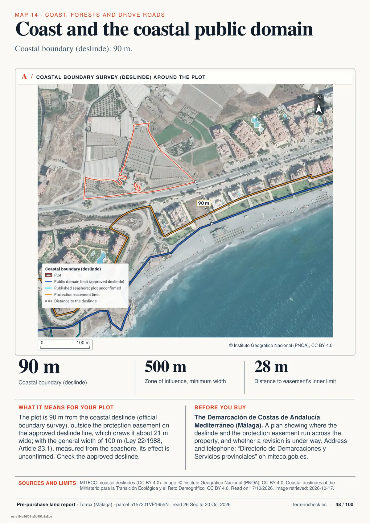
- Use the legend to identify the public-domain boundary, the inner seashore limit and the protection-zone boundary, and whether each comes from an approved or an ongoing deslinde.
- Keep the plan, its status and the deslinde reference.
- Give both references to the Demarcación de Costas and request the approved plan and the position of plot and house.
The viewer has no line for the right of way or the zone of influence. Measuring from the seashore line gives only a guide: the Demarcación confirms the route and width of the right of way, and land-use planning sets the zone of influence.
What should I decide before paying a deposit?
A nota simple costs €9.02 plus VAT on the Colegio de Registradores website and usually arrives within two hours. Ask the Demarcación and the town hall what their certificates cost and how long they take, and set the deposit date for after you have them and have read them.
Use the first checklist for every purchase, the second if any part of the plot is on public-domain land, and the third for planned works or a stretch where serious coastal retreat has been formally declared.
Documents before you pay the deposit: every purchase
- Approved plan, seashore and protection limits, deslinde reference and open boundary proceedings (ask for a certificado de colindancia, which states where the plot lies relative to the deslinde)Demarcación de Costas
- Applicable width and planning; basis for any reduction (see the 20 m table)Town hall and Demarcación de Costas
- Nota simple, discrepancies with the plan and deposit refund termsLand Registry and your own lawyer
- Construction dates, licences, required authorisations, any legalisation, and enforcement files or demolition orders for the house and later worksSeller, town hall and Demarcación de Costas
- Public access to the sea, right of way and existing gates, walls and fencesTown hall and Demarcación de Costas; compare the plan with the site
If any part of the plot or its buildings is on public-domain land (concession)
- Full title with the approved use (a home?), expiry date, extension decisions, any occupation fee (canon) and arrears, and what happens to the works when it ends: removal at the holder’s cost, or kept and handed to the State free (article 72; a DT 4ª.2 house on public-domain land is demolished)Seller and the Demarcación or, where management was transferred, the regional government (e.g. Galicia since 1 July 2025, Royal Decree 394/2025)
- Written confirmation that you meet its conditions, obtained before the transfer (article 70.2)Authority managing the concession
- If the seller inherited the concession: proof that they notified the authority of the death and their intention to take over within four yearsSeller and that authority
- Mortgages or court attachments (embargos) on the concession, and proof that the lender or creditor notified the authority beforehand (article 70.3)Seller and that authority
Renovation plans and declared coastal retreat
- Works under DT 4ª.2: compliance declaration (declaración responsable) filed before the building licence, as explained under existing housesRegional government or Demarcación; confirm the office in your region
- Works affecting the right of way: prior favourable State reportDemarcación de Costas; confirm other permissions needed
- Ministerial order declaring regresión grave (a formal declaration that the coastline is retreating seriously), published in the BOE, if applicable (article 13 ter)Demarcación de Costas
Do not pay until you have the documents confirming the boundary, the house’s legal status and, where applicable, approval to transfer the concession to you. With your lawyer, write into any reservation agreement or deposit contract which checks the purchase depends on, the deadline for them, and a full refund if any check fails or a document does not arrive.
What does a concession grant, and how is it transferred?
Coastal public-domain land cannot be sold or acquired through long possession (article 7). A concession allows occupation; it does not grant ownership.
A revised deslinde bringing land into the public domain gives its owners a 75-year concession without an occupation fee, unless renounced (article 13 bis.2).
Owners whose land became public in 1988 were granted a concession: 30 years, extendable by another 30, if a final court judgment had confirmed their ownership before the law came into force (DT 1ª.1); 30 years for certain registered owners (DT 1ª.2). Check the concession actually granted, when its term started and any extension.
On a stretch the State has declared in regresión grave (serious coastal retreat) by ministerial order in the BOE, Spain’s official gazette (article 13 ter), no new rights to occupy public-domain land are granted; the exception for certain public services does not permit private homes. There, existing buildings lose their occupation right if reached by the sea or at definite risk of being reached (article 13 ter.4).
Any concession may be revoked where its works or installations face a definite risk of being reached by the sea (article 78.1.m). Revocation ends the right to occupy public-domain land; it does not touch private land that lies only in the protection zone.
Under article 2 of Law 2/2013, holders of concessions granted before that law, and of rights under the Coastal Law’s DT 1ª, can apply for an extension before expiry. It can reach 75 years, but how the term is counted depends on the regime and the dates: from the application under Law 2/2013, or from the original grant including every extension under article 20.4 of the national climate change law (Ley 7/2021 of 20 May). Port service zones are excluded. Before paying, ask the authority managing the concession to confirm the exact expiry date in writing.
For a sale, obtain written confirmation before the transfer that the buyer meets the concession’s conditions (article 70.2). If the seller inherited the concession, check that they notified the authority of the death and their intention to take over within four years; without it, the concession ends.
What changes in Andalusia?
In Andalusia, anything built without permission on public-domain land, in the protection zone or on rustic land in the zone of influence is not protected from enforcement by the passage of time: the authorities can still require it to be put right, including demolition (Andalusia’s planning act, LISTA, Law 7/2021 of 1 December, article 153.2). In the zone of influence this applies until national coastal law sets its own rule (LISTA, DT 6ª). The rule that treats buildings from before 1975 as licensed does not apply on public-domain land or in the easements (LISTA, DT 5ª.3). Ask the town hall or the Junta de Andalucía (the regional government) for any enforcement file on the house.
Which other coastal zones affect the plot?
| Zone | Width and starting point | What it limits | What to request |
|---|---|---|---|
| Public right-of-way easement | 6 m from the inner seashore limit; up to 20 m where passage is difficult or dangerous | Open to walkers and rescue vehicles, except in specially protected spaces. May accommodate a promenade; exceptional public-domain works require a replacement strip on equivalent terms (article 27). | Seashore boundary, route and any replacement strip. |
| Zone of influence | Set by planning: at least 500 m from the inner seashore limit | Planning must avoid development that forms a visual barrier along the coast; density cannot exceed the municipal average for suelo urbanizable programado or apto para urbanizar, categories of developable land (article 30.1.b). | Applicable plan, zone boundary and reference density. |
Check whether public access to the sea crosses or borders the plot, and compare the plan with existing gates, walls and fences. Access cannot be cut off without an equivalent alternative (article 28.4). The right of way must stay clear, apart from the exceptions above (article 27). Fences and walls in the first 20 m of protection are allowed only on the conditions set by regulation (Coastal Law, article 24.2). Check this before counting on the whole garden as private and fenced.
For planning classifications, read about rustic, urban and developable land.
What do the Land Registry and the deslinde file tell you?
The Land Registry must refuse to record a plot outline that overlaps the coastal public domain, wholly or partly (Mortgage Law, article 199.1), so any mismatch between the nota simple and the Costas plan must be resolved before completion.
A deslinde can start on the administration’s initiative or on request; neighbouring owners are heard, and the start of the procedure is noted in the Land Registry (article 12.1–12.4).
If an approved deslinde took in part of the plot, a civil claim to recover it must be brought within five years of approval (article 14); check whether that period has already run.
You can enlarge the Torrox extract or browse the sample report. Near watercourses or on low ground, also check SNCZI flood zones.
You can check your plot with TerrenoCheck; clarify the approved boundary and title with the responsible authority.