Pillar: Planning and buildings
Is my non-developable plot in Spain ordinary or specially protected?
On this page
The municipal plan decides, using the category names of its region's planning law; no national rule does. Spain's Land Act (TRLSRU, art. 21.2.a) only lists the land a plan must keep out of development as a minimum. Andalusia has four categories of rustic land, Castile and León up to ten and Madrid a single, protected class. Ask the town hall for yours in writing (art. 5.d).

English listings say "rustic", "rural" or "non-developable" for what Spanish laws call "suelo rústico", "suelo rural" or "suelo no urbanizable": land the plan keeps out of urban development. Inside it, the category separates land protected by a law or by the plan from land that is simply outside the town's growth area, and the uses you can apply for depend on it.
The word "rústica" on a Catastro (cadastre) record does not answer the question. There, urban or rustic depends on the nature of the land for cadastral purposes, with no protection categories (Catastro Act, art. 7). The general uses of rustic land are in what you can do on rustic land.
What national law requires and what it leaves to the regions
Under national law all land is in one of two basic situations: rural or urbanised (TRLSRU, art. 21.1). Land that territorial and town planning preserves from development is rural in every case, and it must include at least (art. 21.2.a):
- land excluded from development by legislation protecting or policing the public domain, nature or cultural heritage;
- land the plan must protect for its values, "incluso los ecológicos, agrícolas, ganaderos, forestales y paisajísticos" (ecological, farming, livestock, forest and landscape values among them);
- land with natural or technological risks, flooding included.
Regional planning law may add more. The names ("no urbanizable", "rústico", "común", "de especial protección", "preservado") and the number of categories come from each of Spain's seventeen autonomous communities, and the municipality's general plan, or a regional plan where the regional law allows it, decides which category each piece of land falls into.
What four regions call it
| Law | Its name for this land | Categories named in the law | Article and version |
|---|---|---|---|
| Spain (TRLSRU) | Land in a rural situation | None by name: it lists what a plan must preserve as a minimum | Art. 21.2.a; 25.5.2023 |
| Andalusia (LISTA) | Suelo rústico | Four: specially protected by sectoral legislation; preserved because of proven risks; preserved by territorial or town planning; ordinary (común), which is the rest | Arts. 12 and 14.1; 7.4.2026 |
| Madrid region | Suelo no urbanizable de protección | No ordinary (común) category: land under a special protection regime or land that planning considers necessary to preserve for its values | Arts. 13.1 and 16.1; 15.6.2026 |
| Castile and León | Suelo rústico | Up to ten, those the general plan chooses to use: ordinary (común); urban fringe; traditional settlement; with farming, infrastructure, cultural, natural or special protection; extractive activities; irregular settlement | Art. 16.1; 5.12.2025 |
| Valencia region (TRLOTUP) | Suelo no urbanizable, the land of the rural zones | Two: ordinary (común) rural land and specially protected rural land | Arts. 26 and 28.2; 10.8.2026 |
Consolidated texts on the BOE (official gazette) website, read on 12.11.2026; the date is each law's latest published update. Sources: TRLSRU; LISTA, Andalusia; Law 9/2001, Madrid; Law 5/1999, Castile and León; TRLOTUP. Accessed 12 November 2026.
In Madrid, plans that pre-date Law 9/2001 and still show "suelo no urbanizable común" have that land treated under the rules for unsectorised developable land (first transitional provision, c). So the same Spanish phrase on two town-hall maps can carry different rules. The Valencian rules for a detached house are in the guide to non-developable land in the Valencia region. The exceptional uses that Castilla y León law allows on rustic land are in the guide to exceptional uses in Castilla y León.
Where the protection comes from: sectoral laws
The first origin is a sectoral law, which the plan has to respect (TRLSRU, art. 21.2.a):
- Coast. A protection easement of 100 metres inland from the inner limit of the seashore, which can be widened or narrowed in the cases set out in the same article (Law 22/1988, art. 23): Coastal Law.
- Water. A five-metre easement strip and a 100-metre "zona de policía" (control zone) along the banks of public watercourses, both adjustable in the cases of art. 6.2; in the control zone land use and activities are subject to conditions (Water Act, art. 6): river or rambla and flood zones.
- Forests. Forests in the public forest domain are preserved from development; a plan that affects the designation of forest land needs a report from the forestry authority, binding for catalogued or protective forests (Law 43/2003, art. 39): forest land.
- Drove roads. "Vías pecuarias" (historic livestock routes) are public domain of the autonomous communities and cannot be sold, acquired by long possession or seized (Law 3/1995, art. 2): drove roads.
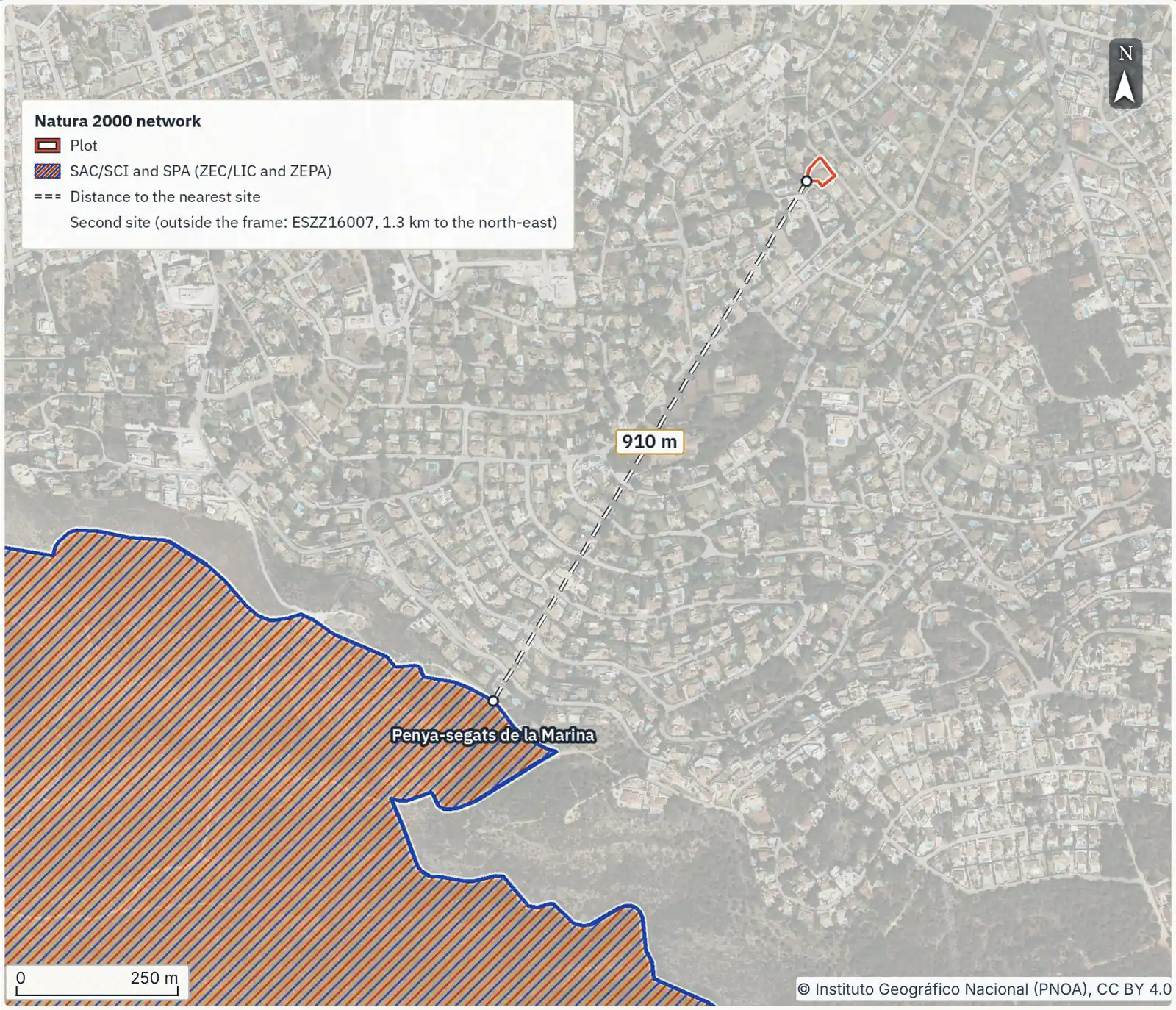
- Protected nature. A town plan that contradicts a natural resources management plan (PORN) must be adapted to it; until then the PORN prevails (Law 42/2007, art. 19.2): Natura 2000.
- Cultural heritage. A historic ensemble, historic site or archaeological zone declared a "Bien de Interés Cultural" (asset of cultural interest) obliges the municipality to draw up a special protection plan or another planning instrument that meets the Act (Law 16/1985, art. 20.1).
- State roads. A building line 50 metres from motorways and dual carriageways and 25 metres from conventional and multi-lane roads, measured from the outer edge of the nearest carriageway, with the special rules of the same article (Law 37/2015, art. 33): distance from a road.
How much land a single layer covers
According to MITECO, the environment ministry, the Natura 2000 network covers about 27.39% of Spain's land territory, and its Sites of Community Importance and Special Areas of Conservation (LIC and ZEC in Spanish) range from 11.74% of the land area of Galicia to 39.80% of the Madrid region, on data to December 2025.
When the plan itself protects
The second origin is the plan itself, which protects land for its values or for risks: that is the land "preservado por la ordenación territorial o urbanística" in Andalusia's LISTA (art. 14.1.c) or rustic land "con protección agropecuaria" (farming protection) in Castile and León (art. 16.1.d).
In Castile and León, where land can fit several categories, the plan places it in the one giving most protection or in several at once; if their rules conflict, the more protective one applies (art. 16.2).
What changes between ordinary and protected land
Within the limits of the laws and the plan, all preserved rural land is to be used for farming, livestock, forestry, hunting or any other use linked to the rational use of natural resources (TRLSRU, art. 13.1). By way of exception, under the procedure and conditions of the regional law, specific acts and uses may be allowed if they are of public or social interest, contribute to rural planning and development or have to be located in the countryside. If your worry is a solar plant or wind farm on neighbouring land, the guide to solar and wind farms near a plot shows where they are announced.
For land with environmental, cultural, historical, archaeological, scientific and landscape values protected by the applicable legislation, the same article adds a limit: its use is always subject to preserving those values and covers only the changes to the land's natural state that the legislation expressly authorises.
‘Protected’ does not mean ‘nothing allowed’, and ‘ordinary’ does not mean ‘you can build’. National law states neither rule: it refers to what the legislation protecting the land authorises and to the conditions of the regional law (TRLSRU, art. 13.1). Those for a house are in rustic, urban and developable land; confirm the ones for your plot with the town hall.
How to find your plot's category
- Identify the plot by its "referencia catastral" (cadastral reference), not by the address in the listing.
- Look up the class in the SIU viewer of the Ministry of Housing and Urban Agenda, which is free and open and holds data for 5,898 municipalities. Its class "Suelo No Urbanizable" groups protected land, land preserved for its values and reserve land: the category cannot be read from it (how to use the viewer).
- Open the classification map of the general plan on the town hall's website or at its planning office ("Urbanismo") and write down the exact Spanish name of the category and the article of the rules that governs it. A translation in a listing is not enough.
- Check the sectoral layers. The SIU viewer includes the maritime-terrestrial public domain service and the river flood risk services; the others are in the viewers named in the guides linked above. If one touches the plot, ask the authority that manages it.
- Ask the town hall for a "cédula urbanística" or planning report stating the class, the category, the permitted uses and the constraints. The law gives "todos los ciudadanos" the right to that information in full, in writing and within a reasonable time, so you can ask before you own the plot (TRLSRU, art. 5.d). Any fee is set by the municipal tax ordinance: deadlines and sample fees are in planning certificate.
A 2 ha plot with a stream on its boundary
A 20,000 m² rustic plot in Castile and León runs along a stream for 120 m. An easement strip 5 m wide takes 600 m² (120 × 5) and a control zone 100 m wide reaches 12,000 m² (120 × 100), more than half the plot (Water Act, art. 6.1). The regional law places the easement strips of river banks in rustic land with natural protection, unless they lie in an urban setting (Law 5/1999, art. 16.1.g). If the plan puts the rest in ordinary (común) rustic land, the plot has two categories, and inside the control zone land use is also subject to the conditions of water law.
Can the category change?
The category changes if the plan or the sectoral boundary changes. National law allows a protected natural area or a Natura 2000 site to be reduced, or land to be taken out of it, only where changes caused by its natural evolution, scientifically demonstrated, justify it (TRLSRU, art. 13.3).
A fire does not release the land either. The Forests Act bans changing the forest use of burnt forest land for at least 30 years, with the exceptions in its art. 50.1. Madrid's law bars moving protected land damaged by fire or environmental harm into another class for the thirty years after the damage, unless an Act of the Madrid Assembly authorises it beforehand (Law 9/2001, art. 16.3).
If you are told it ‘will be reclassified’
Bear in mind that national law, when it values rural land in a compulsory purchase and in the other cases of its art. 34, leaves out expectations of building rights and uses that planning has not yet fully carried out (TRLSRU, art. 36.2). That rule does not set the price of a private sale.
- You have the exact Spanish name of the category under the plan and the article of the rules that governs it.
- You know whether the protection comes from a sectoral law, from the plan or from both.
- You have checked the plot against the coast, watercourse, forest, drove-road, protected-area, heritage and road layers.
- The town hall has answered in writing about the use you intend.
- The deposit contract makes the purchase conditional on that answer.
With the cadastral reference you can order the report for the plot and take the layers, already checked, to the town hall when you ask about the category and each constraint.
Common questions
Is rustic land the same as non-developable land?
It depends on the region. Andalusia and Castile and León call it "suelo rústico" (LISTA, art. 12; Law 5/1999, art. 10.1); the Valencia region, "suelo no urbanizable" (TRLOTUP, art. 28.1), and Madrid, "suelo no urbanizable de protección" (Law 9/2001, art. 13.1). National law speaks of land in a rural situation, which also includes developable land until its urbanisation works are finished (TRLSRU, art. 21.2.b).
Can I build on specially protected non-developable land?
There is no single answer. On land with protected values national law admits only the changes to its natural state that the protecting legislation expressly authorises (TRLSRU, art. 13.1), and each region adds its own rules: in the Valencia region, plans include a ban on building "cuando proceda", where appropriate (TRLOTUP, art. 26.c). Ask the town hall to answer in writing about the specific works.
Where can I see whether my plot is ordinary or protected land?
On the classification map of the municipality's general plan and in its planning rules. The ministry's SIU viewer gives a first reading of the class, but it groups protected land, preserved land and reserve land under "Suelo No Urbanizable". The answer to rely on for a purchase is the town hall's planning certificate or report (TRLSRU, art. 5.d).
Does the Catastro show whether my land is protected?
No. The Catastro separates urban and rustic property by the nature of the land as its own Act defines it (Catastro Act, art. 7) and does not record the plan's categories. A plot shown as "rústica" in the Catastro can be in any of them.
Can protected land be reclassified for development?
It depends on who protects it. A protected natural area or Natura 2000 site can be reduced only for changes due to its natural evolution, scientifically demonstrated (TRLSRU, art. 13.3). Burnt forest land cannot change its forest use for at least 30 years, with the exceptions of art. 50.1 of the Forests Act. Land the plan protects by its own decision changes only through an amendment or revision of the plan.
Keep reading
Check this on your own plot
Pin the plot on the map and confirm the cadastral reference: the report gathers the public data and official maps for it, each with its source and date. It does not replace the land registry extract, the notary or a tax adviser. €29 VAT included.